Go to ET GeoWizards 12.x User Guide
Transfers the attributes from one polygon layer (source) to another (target) based on their spatial location (overlay). The user specifies the method for transferring the attributes of each field of the source polygon attribute table.
Inputs:
Outputs:
Transfer Methods:
 |
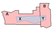
The Source dataset has two polygons A and B. The Target dataset has a single polygon - Z. The portion of the Target polygon that intersects with polygon "A" of the Source layer is polygon X, and the portion that intersects with polygon B is polygon Y. |
population_Z = population_A * area_X / area_A + population_B * area_Y / area_B
rainfall_Z = (rainfall_A * area_X + rainfall_B * area_Y ) / area_Z
IF area_X / area_Z > area_Y / area_Z THEN soiltype_Z = soiltype_A
IF area_X / area_Z < area_Y / area_Z THEN soiltype_Z = soiltype_B
Notes:
Example:
 |
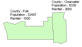
Source Data Transfer Methods
|
 |
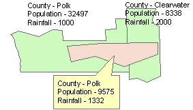
Results |
ToolBox
implementation
(Go to TOP)
Command line syntax
ET_GPTransferAttributes <target_dataset>
<source_dataset> <out_feature_class> <Field {Transfer Method};Field
{Transfer Method}...>
Parameters
| Expression | Explanation |
|---|---|
| <target_dataset> | A Polygon feature class or feature layer |
| <source_dataset> | A Polygon feature class or feature layer. |
| <out_feature_class> | A String - the full name of the output feature class (A feature class with the same full name should not exist) |
| <Field {Transfer Method};Field {Transfer Method}...> | A list of the fields to be transferred and the transfer method for each field. |
Scripting syntax
ET_GPTransferAttributes (target_dataset, source_dataset, out_feature_class, fields to transfer)
See the explanations above:
<> - required parameter
{} - optional parameter
| Copyright © Ianko Tchoukanski |