Go to ET GeoWizards 12.x User Guide
Uniform Points In Polygons
Go to ToolBox
Implementation
Generates uniform (regularly spaced) points located in the polygons of the input polygon
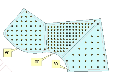
dataset. The number of points per polygon can be constant or different for each polygon - based on the values in a numeric field of the input
polygon feature class. The distance between the points is interpolated for each
polygon. The user can specify the rotation angle for the resulting point grid.
Inputs:
- A polygon feature class
- The number of points per polygon can be input
in one of the following ways
- A numeric field which values will be used
to get the number of points to be generated per polygon.
- A constant number
- Optional: Minimum Distance from boundary - no point will be generated
that is closer than this tolerance to the boundary of the polygon.
- Rotation angle
- Constant for all polygons - (in degrees starting from East
anti-clockwise)
- From field - different rotation angle for each field (in degrees
starting from East anti-clockwise)
- Along the longest axis of each polygon
- Along the longest side of each polygon
Outputs:
- New Point feature class.
- The following fields are added to the
attribute table of the resulting feature class.
- [ET_ID] - the ID of the original polygon
- [ET_X] - the X coordinate of the point
- [ET_Y] - the Y coordinate of the point
- [ET_Dist] - the distance between the generated points (constant
for the points in each polygon)
Illustration:
ToolBox
implementation
(Go to TOP)
Command line syntax
ET_GPUniformPointsInPolygons<input_dataset>
<out_feature_class> {number_points_field} {number_points} {min_distance}
{angle_from} {rotation_angle} {angle_field}
Parameters
| Expression |
Explanation |
| <input_dataset> |
A
Polygon feature class or feature layer |
| <out_feature_class> |
A String
- the full name of the output feature class. |
| {number_points_field} |
A String representing the name of a
numeric field which values will be used
to get the number of points to be generated per polygon. |
| {number_points} |
A Double representing the number of
points for to be created in each polygons (the same for all polygons) |
| {min_distance} |
A Double specifying the minimum
distance from boundary. |
| {angle_from} |
A String defining how the rotation
angle will be specified
- "Constant" - Constant for all polygons - (in degrees starting
from East anti-clockwise)
- "From field" - different rotation angle for each field (in
degrees starting from East anti-clockwise)
- "Longest Axis" - Along the longest axis of each polygon
- "Longest Side" - Along the longest side of each polygon
|
| {rotation_angle} |
A Double - specifying the rotation
angle for all polygons. |
| {angle_field} |
A String - the name of the field to be
used as source for rotation angle. |
Scripting syntax
ET_GPUniformPointsInPolygons(input_dataset, out_feature_class,
number_points_field, number_points, min_distance, angle_from, rotation_angle,
angle_field)
See the explanations above:
<> - required parameter
{} - optional parameter
| Copyright © Ianko Tchoukanski |