Cleans the dangling nodes from a polyline layer using user specified dangling tolerance
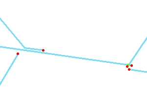
Before Clean Dangles
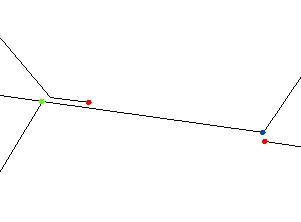
After Clean - No "Nearest Snap" used
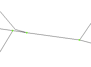
After Clean - "Nearest Snap" used
Parameters
| Expression | Explanation |
|---|---|
| Function Name | CleanDangles |
| <input dataset> | A String representing the input layer. Must be of Polyline type. |
| <output dataset> | A String - the full name of the output layer. |
| <Dangling Tolerance> | A Double representing the tolerance to be used. The polylines with dangling nodes within distance smaller than this value to existing features (depending on the options used) will be extended/snapped to the closest existing feature |
| {Snap Nearest} | A Boolean - if True, the ends of the dangling polylines that could not be snapped to
an existing polyline by extending in the direction of the last segment or to an existing node will be snapped
(if the dangling node is within a distance smaller than the |
| {Fuzzy Tolerance} | A Double representing the Fuzzy tolerance (in the units of the input dataset). |
ETGWPath used in the table below is the full path to ETGWRun.exe (E.G. "C:\Program Files\ETSpatial Techniques\ETGeo Wizards\ETGWRun.exe")
| Language | Syntax |
|---|---|
| Python | subprocess.call([ETGWPath, "CleanDangles", "input dataset", "output dataset", "Dangling Tolerance", "Snap Nearest", "Fuzzy Tolerance"]) |
| .NET using ETGWRun.exe | StartInfo.FileName = ETGWPath StartInfo.Arguments = "CleanDangles" "input dataset" "output dataset" "Dangling Tolerance" "Snap Nearest" "Fuzzy Tolerance" |
| .NET using ETGWOutX.dll | CleanDangles(input dataset, output dataset, Dangling Tolerance, Snap Nearest, Fuzzy Tolerance) |
| ArcPy | arcpy.CleanDangles(input dataset, output dataset, "Dangling Tolerance", "Snap Nearest", "Fuzzy Tolerance") |
Notes:
<> - required parameter
{} - optional parameter
The argument separator for StartInfo.Arguments is space. If a string might contain a space, you need to double quote it.