


Go to ET GeoWizards 12.x User Guide
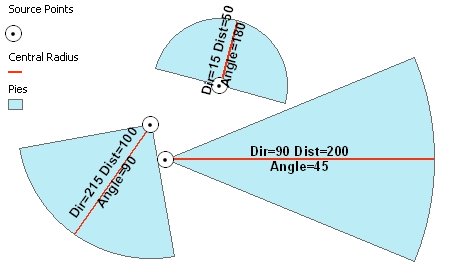
Creates Pie segment polygons from points, pie direction, radius and central angle.
Inputs:
| Polar | North Azimuth | South Azimuth | Quadrant Bearing |
|
|
|
|
Outputs:
Example :
 |
ToolBox
implementation
(Go to TOP)
Command line syntax
ET_GPPointsToPieSegments <input_dataset> <out_feature class> <distance_field> <direction_field> <angle_field> <NorthAzimuth | SouthAzimuth | Polar | QuadrantBearing> <DD | DMS | Radians | Gradians | Gons>
Parameters
| Expression | Explanation |
|---|---|
| <input_dataset> | A Point feature class or feature layer |
| <out_feature class> | A String - the full name of the output feature class (A feature class with the same full name should not exist) |
| <distance_field> | A String representing the name of a field in the in the attribute table of the input dataset. The field has the values for the radius of the circular segments to be created |
| <direction_field> | A String representing the name of a field in the in the attribute table of the input dataset. The field has the values for the directions of the circular segments to be created. The direction defines the central radius of the segment. |
| <angle_field> | A String representing the name of a field in the in the attribute table of the input dataset. The field has the values for the central angle of the pie circular segments to be created. |
| <NorthAzimuth | SouthAzimuth | Polar | QuadrantBearing> | Direction
Type. A String - the type of the output angle for the direction of
the segments. Go to the main page of the function for a description |
| <DD | DMS | Radians | Gradians | Gons> | Direction
Unit. A String - the type of the output angle for the direction of
the segments. Go to the main page of the function for a description |
Scripting syntax
ET_GPPointsToPieSegments (input_dataset, out_feature class,direction_field,distance_field, angle_field, direction_type, direction_unit)
See the explanations above:
<> - required parameter
{} - optional parameter
| Copyright © Ianko Tchoukanski |