Go to ET GeoWizards 12.x User Guide
Eliminate
Go to ToolBox
Implementation
Eliminates unwanted polygons (slivers) by merging them into the neighboring polygons or
deleting them.
Inputs:
- A polygon feature layer
- Selection method
- Attribute query - introduces the standard ArcGIS query builder. The user can select the
polygons to be eliminated using any query expression
- Thickness ratio is expressed as a ratio of the polygon area versus the area of its
minimal bounding square. The ratio will have value of 1 for a square. The smaller the value
is, the thinner the polygon is. It is a good way of identifying thin polygons (possible
slivers).
- Circularity ratio - for a circle the circularity will be 1. The thinner the polygon is
the smaller the circularity will be. This is another way of identifying slivers
- Elimination method
- Delete - will delete all selected polygons (considered slivers)
- Join (Largest area) - will join selected polygons with neighboring polygons that
have the largest area
- Join (Longest boundary) - will join selected polygons with neighboring
polygons with the longest common border .
- Join to the neighbor with the same value
in the selected field as the sliver polygon.
- Identify - will record in the attribute table selected potential slivers. This allows
for visual inspection before proceeding with elimination.
Outputs:
- New polygon feature class with selected polygons eliminated or identified as slivers
- New field is added to the attribute table :
- [ETO_Type]
- The polygons not affected from elimination will have value - "Original"
- The slivers that were not eliminated will have value - "Sliver"
- The polygons that a sliver has been merged to - value - "Changed"
Notes :
- If the source of the original data set is a feature class, to operation can be performed on
the original. If the source is a Coverage or Geodatabase, the only option is creating a
new feature class
- If the option "Calculate statistics" is selected, the next step will contain
valuable statistics - Min, Max and Mean values for the selected method (Thickness ratio or
circularity) that will help the user when assigning the ratio to be used for elimination
- Checked "Update Area and Perimeter" option will cause recalculation of the
Area and perimeter values. The rest of the original attributes are preserved
- Some of the very tiny slivers can be eliminated with the Clean
Polygon Wizard using appropriate value for Fuzzy tolerance, however eliminating larger
slivers using this method is not recommended since some unwanted approximation of the
polygon shapes might occur.
Examples:
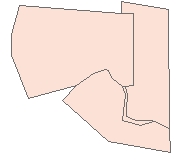
Before Eliminate |
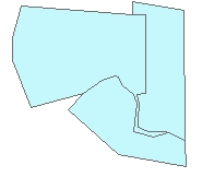
Eliminated with Largest Area option |
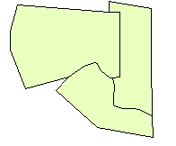
Eliminated with Longest boundary option |
 |
 |
 |
ToolBox
implementation
(Go to TOP)
Command line syntax
ET_GPEliminate <input_dataset>
<out_feature class> <Attrib | Thickness | Circularity> <Delete |
Largest | Longest | Join Field> {SQL_Expression} {thickness_circularity_ratio}
{Join_Field}
Parameters
| Part |
Description |
| <input_dataset> |
A
Polygon feature class or feature layer |
|
<out_feature class> |
A String
- the full name of the output feature class (A feature class with the same full
name should not exist) |
| <Attrib
| Thickness | Circularity> |
Selection
Method. A String
- the method to be used for selection of the polygons to be eliminated. The values
can be:
- "Attrib" - an attribute
query will be used
- "Thickness" - the thickness ratio
will be used for selection. The thickness is expressed as a ratio of the polygon area versus the area of its
minimal bounding square. The ratio will have value of 1 for a square. The smaller the value
is, the thinner the polygon is.
- "Circularity" - the
thickness ratio will be used for selection. For a circle the circularity will be 1. The thinner the polygon is
the smaller the circularity will be.
|
| <Delete
| Largest | Longest | Join Field> |
Elimination
Method. A
String representing the elimination method to be used. The values can be:
- "Delete" - The selected polygons
will be deleted
- "Largest" - The polygons will be
eliminated by joining them to the neighboring polygons that
have the largest area
- "Longest" - The polygons will be
eliminated by joining them to the neighboring
polygons with the longest common border .
- "Join Field" - The polygons will be
eliminated by joining them to the neighboring
polygons with the same value in the selected field as the sliver
polygons.
|
| {SQL_Expression} |
A String - the Where Clause that will be used if "Attrib"
selection method is used. Ignored if any of the other selection methods is
used.
|
| {Join_Field} |
A String -
A String representing the name of the field to be used with the
"Join Field" option.
|
| {thickness_circularity_ratio} |
A Double representing the value of the ratio to be used. If the
selection method is "Thickness" this is the Thickness ratio,
if "Circularity" - this is the Circularity ratio. If
"Attrib" selection method is specified this value is
ignored
|
Scripting syntax
ET_GPEliminate (input_dataset, out_feature class,
selection_method, elimination_method, SQL_Expression,
thickness_circularity_ratio,Join_Field)
See the explanations above:
<> - required parameter
{} - optional parameter
Example Python
script:
import arcpy
arcpy.ImportToolbox("C:/Program Files/ET SpatialTechniques/ET GeoWizards
11.0 for ArcGIS 10.1/ET GeoWizards.tbx")
arcpy.gp.toolbox = "C:/Program Files/ET
SpatialTechniques/ET GeoWizards 11.0 for ArcGIS 10.1/ET
GeoWizards.tbx"
input_dataset = "C:\\data\\pg1.shp"
result = "C:\\data\\fgdb_test.gdb\\eliminate_result"
arcpy.gp.ET_GPEliminate (input_dataset, result,
"Thickness", "Longest","",0.35,"") |
| Copyright © Ianko Tchoukanski |